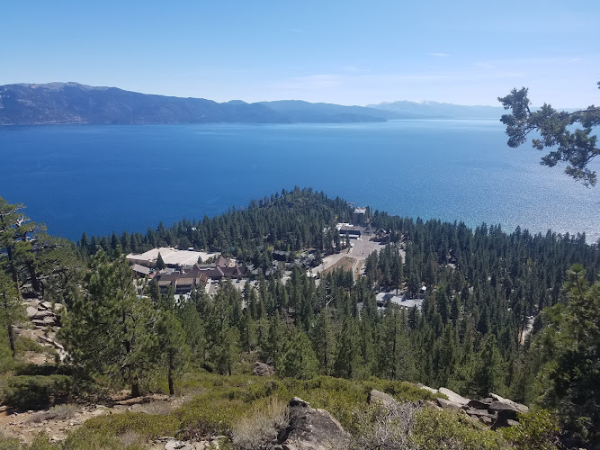
Historic Stateline Fire Lookout is a former forest-fire observation site above Lake Tahoe’s north shore, in the Kings Beach–Crystal Bay border area. The summit lies in Kings Beach, California 96143; walking access starts at an unnumbered, gated Forest Service road above Reservoir Drive in Crystal Bay, Nevada. Established in the 1930s, the lookout rewards a short, uphill walk with broad lake views and interpretive displays about Tahoe’s forests. The original tower was removed in 2002: visitors come for the historic site and panorama, not a tower climb.
What to Expect at Historic Stateline Fire Lookout
The principal approach follows a paved former service road through pine and fir forest, climbing steadily rather than negotiating a technical mountain trail. Allow approximately 1.5 miles for an out-and-back visit with the short summit paths, depending on where you park. At roughly 7,000 feet above sea level, the lookout sits well above Tahoe’s shoreline; even this modest walk can feel strenuous if you have just arrived from sea level.
At the top, a short interpretive circuit connects viewing areas, benches, and panels explaining the landscape and its human history. Look southwest across the Kings Beach shoreline and west toward the mountain backdrop beyond the lake. The concrete lookout footprint helps explain how this compact summit once supported fire detection. There is no staffed museum, café, or equipment rental: the experience is an outdoor walk, a history stop, and time spent studying the changing light on the water.
- Former lookout site: The surviving footprint marks the position of the dismantled fire-observation structure.
- Lake Tahoe panorama: Elevated views take in the north-shore settlements, open water, and surrounding Sierra ridges.
- Interpretive panels: Outdoor displays introduce the forest landscape and the area’s historical development.
- Paved forest approach: A gated service road provides a straightforward walking route, although the sustained incline matters.
- Summit benches: Seating lets visitors pause, recover from the climb, and enjoy the outlook without standing throughout.
Historic Stateline Fire Lookout at a Glance
| Detail | Information |
|---|---|
| Address | Unnumbered Forest Service access road above Reservoir Drive, Crystal Bay, NV 89402; summit in Kings Beach, CA 96143 |
| Neighborhood / Area | North Lake Tahoe, California–Nevada state-line ridge |
| Operating Hours | Monday–Sunday: open 24 hours; daylight visits recommended, subject to forest closures and weather |
| Admission / Price Range | Free admission; $; no ticket or reservation required |
| Recommended Visit Duration | 1 to 1.5 hours |
| Nearest Transit / Parking | TART Mainline to Crystal Bay; uphill walk to trailhead. Limited roadside parking near the access gate; keep driveways and emergency access clear. |
| Official Website & Phone | Lake Tahoe Basin Management Unit; +1 530-543-2600, Forest Service office |
Visiting Tips, Getting There & Nearby Pairings
Arrive in the morning for cooler climbing temperatures and easier roadside parking. The vehicle gate is not a public parking entrance; do not block it or park on private property. Transit travelers can use the TART Mainline along State Route 28 to Crystal Bay, then walk uphill through residential streets to the approach. The paved surface is useful for sturdy strollers, but the sustained grade, possible broken pavement, and winter ice mean this is not a reliably barrier-free wheelchair outing. Summit benches provide rest stops; there is no public elevator or vehicle shuttle.
Carry water, sun protection, and a layer for exposed summit winds; do not depend on toilet availability. Keep dogs leashed and remove their waste. Spring snow can linger, summer brings dry footing and wildfire-smoke risks, and autumn often offers cooler walking before winter ice returns. The route has no street lighting, so descend before dark. For nearby pairings, Crystal Bay Club and the State Route 28 dining strip around the state line are roughly 10–15 minutes downhill from the lower access area—not from the summit. Kings Beach’s public waterfront is better treated as a separate short drive or bus ride.
Frequently Asked Questions
What are the hours, and when should I visit?
The outdoor site is open 24 hours, although emergency forest closures can restrict access. Choose daylight, preferably morning, and check Forest Service alerts after storms or during wildfire season.
Are tickets or reservations required?
Admission is free, and ordinary independent visits require neither tickets nor reservations. There is no staffed admission booth or paid tower-climbing experience.
How much time should I allow?
Budget 60–90 minutes for the climb, interpretive circuit, photographs, and descent. Add time if walking from the highway bus stops or accompanying children who need frequent breaks.
Is the walk suitable for families and wheelchairs?
Families comfortable with an uphill walk generally find the paved approach manageable; supervise children near exposed edges. Pavement alone does not make the route wheelchair accessible, and snow or ice substantially increases the difficulty.
When planning your Incline Village travel guide or browsing verified attractions in Incline Village, pair this stop with standout local spots including Bite Restaurant, Wing's Korean Chicken, Azzara's, and Border House at Crystal Bay (0.6 km away).