
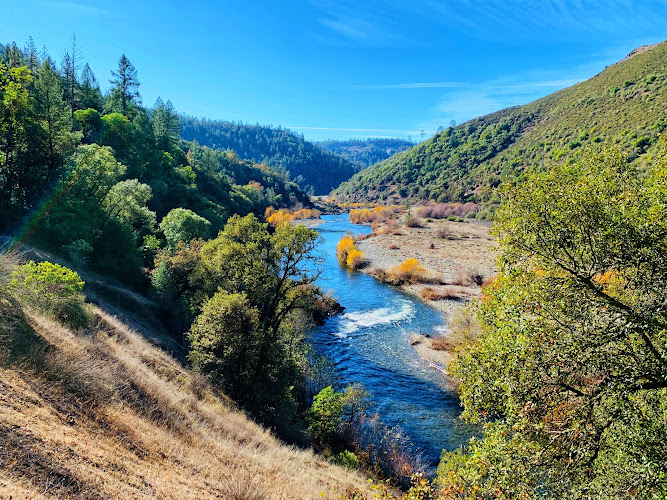
Quarry Road Trail is a rugged American River canyon route at 150 CA-193, Auburn, CA 95603, in Auburn’s Confluence area of the Sierra Nevada foothills. Part of Auburn State Recreation Area, established in 1975 on land assembled around the proposed Auburn Dam project, the trail follows an old road corridor through oak woodland and exposed rock above the river. Travelers come for a close-up Gold Country landscape, big canyon views, and a quieter alternative to Auburn’s better-known river-access paths.
What to Expect at Quarry Road Trail
This is a natural-surface, shared-use trail rather than a landscaped promenade. The route moves through blue oak and interior live oak woodland, manzanita, gray pine, and open slopes where the canyon’s hard, weathered rock is fully visible. Expect uneven dirt, loose stones, seasonal ruts, and grades that feel more demanding in heat. The scenery changes quickly between shaded tree cover and exposed overlooks, with the American River canyon as the defining backdrop.
Quarry Road Trail makes sense for hikers who want to combine a short out-and-back with the wider Auburn State Recreation Area trail network. Carry a paper or downloaded map, as canyon terrain can interrupt signal and junctions are not an interpretive exhibit route. The recreation area protects the North and Middle Fork American River corridor, a landscape shaped by Nisenan homelands, Gold Rush-era mining, and later dam planning; treat old cuts, loose rock, and riverbanks as sensitive terrain rather than climbing features.
- Old road alignment: A broad historic corridor gives the trail its name and a more gradual feel than narrow single-track paths.
- American River canyon views: Open stretches reveal steep foothill slopes, rock outcrops, and the river corridor below.
- Oak-and-pine habitat: Blue oak, live oak, manzanita, and gray pine frame the route, especially attractive in cooler months.
- Shared-use etiquette: Hikers, mountain bikers, and equestrians may use Auburn SRA trails; stay alert around blind corners and yield appropriately.
- Confluence setting: The trailhead is close to the North Fork and Middle Fork American River recreation area and Foresthill Bridge approaches.
Quarry Road Trail at a Glance
| Detail | Information |
|---|---|
| Address | 150 CA-193, Auburn, CA 95603 |
| Neighborhood / Area | Confluence area, Auburn State Recreation Area, American River canyon |
| Operating Hours | Listed open 24 hours daily; use daylight hours for safe trail travel and observe posted park closures. |
| Admission / Price Range | No separate trail ticket; state-park day-use parking fee may apply at designated lots. $ |
| Recommended Visit Duration | 1.5 to 2.5 hours for a relaxed out-and-back with viewpoint stops |
| Nearest Transit / Parking | Trailhead parking off CA-193; Auburn Amtrak station is about 4 miles away, requiring a taxi, rideshare, or bicycle connection. |
| Official Website & Phone | California State Parks: Auburn SRA Trails; +1 916-653-6995 |
Visiting Tips, Getting There & Nearby Pairings
Arrive early, particularly from late spring through early fall, when exposed canyon slopes become hot well before midday and trailhead spaces fill around weekends. There is no need for a timed entry reservation for the trail itself, but check current closures, fire restrictions, and parking rules through California State Parks before leaving Auburn. Take more water than you expect, wear grippy footwear, and do not rely on river access as a cooling stop: currents and cold-water hazards can be serious.
Driving is the practical way to reach the CA-193 trailhead; the nearest intercity rail stop is Auburn Amtrak, not a walkable last mile. The trail surface is not step-free: loose rock, uneven grades, and natural obstacles make it unsuitable for standard wheelchairs and difficult for most strollers. For a gentler outing, enjoy the accessible facilities available at developed park areas rather than attempting the canyon track. Within roughly 5 to 15 minutes on foot, pair a hike with American River Confluence viewpoints, the approaches to the 730-foot-high Foresthill Bridge, and riverbank scenery where the North and Middle Forks meet.
Frequently Asked Questions
What are Quarry Road Trail’s hours, and when is the best time to go?
The trail is listed as open 24 hours daily, though daylight is the sensible and safest time to hike because there is no trail lighting. Start early in warm weather; winter and spring mornings are cooler and often greener, but check conditions after storms.
Does Quarry Road Trail require a ticket or reservation?
There is no separate admission ticket or timed-entry reservation for the trail. A California State Parks day-use parking charge may apply at designated lots, so bring a payment method and confirm the current fee and any restrictions before arrival.
How much time should I budget for the hike?
Allow 1.5 to 2.5 hours for an unhurried out-and-back, including time for photographs, water breaks, and careful footing on uneven ground. Add time if connecting to other Auburn State Recreation Area routes or stopping at the confluence.
Is Quarry Road Trail suitable for children, strollers, or wheelchairs?
Confident older children can enjoy it with close supervision, water, and attention near steep terrain, but it is not a stroller-friendly or wheelchair-accessible path. Its unpaved surface, loose rock, and variable grades require stable footwear and sure footing; review California State Parks accessibility information when planning a visit.
When planning your Auburn travel guide or comparing verified attractions and hiking area in Auburn, pair this stop with standout local spots including Red Lion Inn & Suites Auburn CA, Auburn Gold Country RV Park, AASRA Hotel, and Lake Clementine Trail (0.4 km away).


