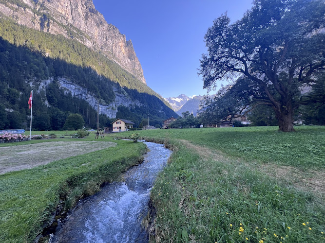
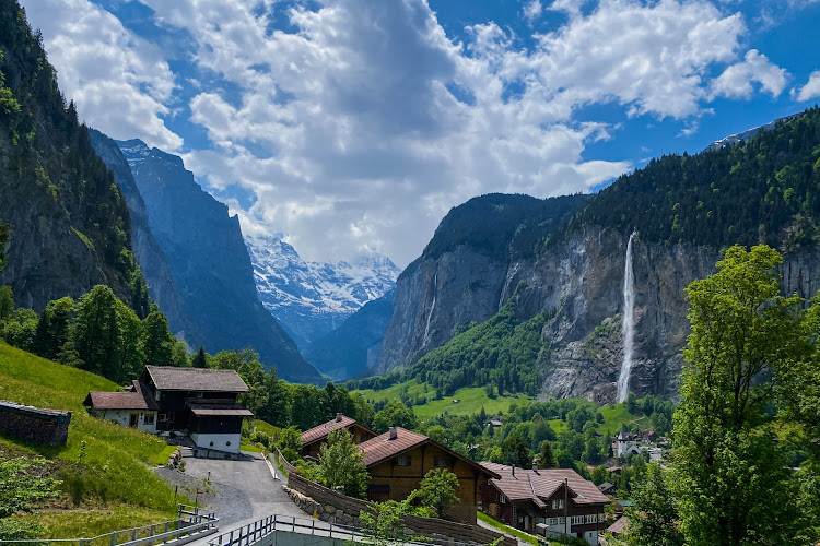
Staldenbachfall is a natural waterfall near Stechelberg in the upper Lauterbrunnen valley, at 3824 Lauterbrunnen, Switzerland. It has no numbered street address; its mapped position is 46.5423598, 7.9097884. Set against the rocky slopes of this glacially carved Bernese Oberland valley, it offers a quieter waterfall stop than the better-known Staubbachfall farther north. Travelers come for falling water, mountain scenery, and the chance to build a short nature stop into a longer valley walk.
What to Expect at Staldenbachfall
Think of Staldenbachfall as an outdoor landscape feature rather than a developed attraction. The experience centers on the Staldenbach stream descending the valley flank, with exposed rock, vegetation, and changing water levels shaping the view. Snowmelt and rainfall influence its appearance: spring and early summer generally bring stronger runoff, while prolonged dry weather can produce a more modest flow. Do not plan around a fixed cascade height or expect the engineered viewing galleries found at Trümmelbach Falls.
The surrounding landscape explains much of the appeal. Ice excavated Lauterbrunnen’s steep-sided, U-shaped valley; smaller tributary streams now descend its flanks toward the Weisse Lütschine. Around Stechelberg, the valley narrows and the village gives way to mountain walking country. Combine broad views of the enclosing cliffs with closer studies of water crossing dark rock. Staldenbachfall is distinct from Staubbachfall beside Lauterbrunnen village, so check the coordinates before setting out rather than relying on similar-sounding waterfall names.
- Staldenbach cascade: The waterfall itself is the focus; its volume and photographic character change with recent weather.
- Glacial valley scenery: Steep rock walls reveal the large-scale landscape that makes the Lauterbrunnen valley distinctive.
- Stechelberg setting: The upper-valley location suits travelers continuing beyond Lauterbrunnen’s busiest village sights.
- Weisse Lütschine walks: Nearby riverside routes provide a natural extension without requiring a mountain railway journey.
- Free outdoor visit: There is no waterfall admission ticket, making this a straightforward addition to a walking itinerary.
Staldenbachfall at a Glance
| Detail | Information |
|---|---|
| Address | Near Stechelberg, 3824 Lauterbrunnen, Switzerland; coordinates 46.5423598, 7.9097884; no numbered street address |
| Neighborhood / Area | Upper Lauterbrunnen valley, Bernese Oberland |
| Operating Hours | Monday–Sunday: open 24 hours as an outdoor natural site; visit in daylight and observe local closures |
| Admission / Price Range | Free; $ budget tier, excluding transport and parking |
| Recommended Visit Duration | 20–40 minutes at the waterfall; allow additional walking time |
| Nearest Transit / Parking | PostBus 141 from Lauterbrunnen station toward Stechelberg; Stechelberg, Hotel is a useful approach stop. Paid parking is available at the Stechelberg cableway terminal, farther down-valley. |
| Official Website & Phone | Lauterbrunnen municipal information; no dedicated waterfall telephone |
Visiting Tips, Getting There & Nearby Pairings
Arrive during daylight, ideally with enough time to retrace your approach before evening. Cloudy conditions can make waterfall photography easier by reducing contrast between bright water and shaded rock. From Lauterbrunnen railway station, use PostBus route 141 toward Stechelberg and check departures through SBB. Choose your stop and walking route using the waterfall coordinates. Drivers should use designated parking rather than farm entrances or passing places; the cableway car park requires a longer walk than an arrival near Stechelberg village.
Wear grippy footwear: rural paths and streamside ground can be uneven, muddy, or slippery. A mapped waterfall location should not be mistaken for a wheelchair-accessible viewing platform; wheelchair users and families with strollers should confirm the approach surface locally and favor surfaced valley routes. Keep away from the stream channel during heavy rain or rapid snowmelt. For nearby pairings, explore the Weisse Lütschine river corridor and Stechelberg’s meadow edges, with short five- to fifteen-minute walking additions possible along your approach. Stechelberg village adds a useful refreshment stop; Trümmelbach Falls requires a separate journey farther down-valley.
Frequently Asked Questions
When is Staldenbachfall open, and when should I visit?
The natural site has no staffed opening schedule and is listed as open around the clock. Visit in daylight; spring and early summer often offer stronger water flow, while winter ice and snow can complicate access.
Do I need tickets or a reservation?
No admission ticket or reservation is required for Staldenbachfall. Budget separately for bus fares or paid parking, and respect any temporary path restrictions.
How much time should I allow?
Allow 20–40 minutes for looking, photography, and a short pause. Add your outward and return walking time, especially if starting at the Stechelberg cableway terminal rather than near the village.
Is it suitable for children and wheelchair users?
Children can enjoy the landscape with close supervision beside water and uneven ground. Wheelchair users should arrange a locally checked route rather than assume step-free access to the waterfall; outdoor footwear matters more than any dress code.
When planning your Lauterbrunnen travel guide or browsing verified attractions in Lauterbrunnen, pair this stop with standout local spots including Trummelbach Waterfalls, Hasenbach Falls, Bergrestaurant Allmend, and Mattenbachfälle (0.8 km away).