
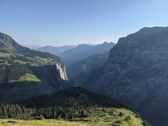
Tanzbödeli is a high alpine lookout at 3826 Lauterbrunnen, Switzerland, above the Stechelberg end of the Lauterbrunnen Valley in the Bernese Oberland. Reached on foot rather than by road, this grassy mountain shelf rewards fit hikers with an open panorama over the Lauterbrunnen and Sefinen valleys, their sheer limestone walls, waterfalls and high Alpine summits.
What to Expect at Tanzbödeli
This is not a built attraction with a ticket desk, café or fenced viewing platform; Tanzbödeli is a destination on demanding mountain footpaths. The classic outing climbs steeply from the Stechelberg/Gimmelwald side through forest and pasture before the trees fall away at the viewpoint. The reward is the striking contrast between the deep, narrow Lauterbrunnen Valley and the wilder Sefinen Valley, with long sightlines across dark conifer slopes, pale rock faces and snow-streaked ridges when conditions are clear.
Many hikers make Tanzbödeli part of a longer loop or through-hike involving Obersteinberg, rather than turning around at the viewpoint. Expect sustained ascent, uneven ground, roots, rocks and occasional short sections where hands may be useful for balance. Beyond the lookout, mountain paths can become narrow and exposed; route choice should match experience, weather and the day’s snow conditions. Carry water and food, as there are no services at Tanzbödeli itself, and enjoy the panorama without approaching steep grassy edges.
- High grassy lookout: An open pasture shelf above the treeline gives the wide-angle view that forested lower trails cannot.
- Lauterbrunnen Valley panorama: Look across the famous U-shaped valley, dramatic vertical cliffs and a dense concentration of seasonal waterfalls.
- Sefinen Valley views: The viewpoint also faces the more secluded valley south of Mürren and Gimmelwald, framed by rugged Alpine slopes.
- Obersteinberg connection: Strong hikers can continue on mountain trails toward Obersteinberg for a longer, more varied day in the backcountry.
- Photography in changing light: Early sun and late-afternoon side light define the valley walls; cloud can move in quickly around the higher ridges.
Tanzbödeli at a Glance
| Detail | Information |
|---|---|
| Address | Mountain viewpoint, 3826 Lauterbrunnen, Switzerland; no street address or road access |
| Neighborhood / Area | Above Stechelberg, Lauterbrunnen Valley, Bernese Oberland |
| Operating Hours | Open terrain with no formal hours; visit in daylight and only when trails are snow-free and conditions are suitable |
| Admission / Price Range | Free; no admission charge. Budget for rail, cable-car or PostBus travel if used to reach a trailhead |
| Recommended Visit Duration | 4 to 7 hours for an out-and-back hike or longer Obersteinberg route, depending on start point |
| Nearest Transit / Parking | PostBus 141 to Stechelberg, Schilthornbahn; limited paid parking is available at the Stechelberg cable-car base |
| Official Website & Phone | No dedicated venue website or telephone; use the SBB journey planner for public-transport connections |
Visiting Tips, Getting There & Nearby Pairings
Start early, particularly in summer, when afternoon thunderstorms are common in the Alps and hikers may be descending wet, slippery ground. Check the local forecast, trail condition reports and cable-car operating status before setting out. Sturdy hiking boots with grip, layers, rain protection, a charged phone and sufficient water are essential. There is no reservation system for Tanzbödeli; the planning priority is a safe weather window and enough daylight for the return.
From Lauterbrunnen station, PostBus 141 runs through the valley to Stechelberg, Schilthornbahn, a practical access point for routes toward Gimmelwald and the high paths. Drivers should leave vehicles in Stechelberg rather than expecting parking near the viewpoint. Tanzbödeli has no step-free route, toilets, benches, lift or wheelchair-accessible surface: steep gradients, rocky trail sections and exposed terrain make it unsuitable for wheelchairs and most strollers. Nearby mountain stops include Gimmelwald, about 2.2 kilometres away, and Wasserfall Sprutz, about 2.4 kilometres away; Obersteinberg is a natural pairing for experienced walkers on the longer route.
Frequently Asked Questions
When is Tanzbödeli open, and what is the best time to go?
Tanzbödeli has no gate or set operating hours, but it should be treated as a daylight-only mountain hike. Summer and early autumn generally offer the most practical access after snow has cleared; begin early for firmer weather and more time to descend before afternoon storms.
Does Tanzbödeli charge admission or require a reservation?
Access to the viewpoint is free and no reservation is required. Costs depend on how you reach the trailhead, including PostBus, rail or cable-car fares, while food and water should be purchased before starting because there are no facilities at the lookout.
How much time should I allow for the hike?
Allow at least 4 to 7 hours for a Tanzbödeli hike, with the total changing significantly by trailhead, pace and whether you continue via Obersteinberg. Build in time for photo stops, route-finding and a conservative descent on steep terrain.
Is Tanzbödeli suitable for families or visitors with limited mobility?
The viewpoint is best for confident, properly equipped hikers with good fitness; it is not a casual roadside stop. Older children experienced with steep mountain trails may manage a suitable route with close supervision, but there is no wheelchair or stroller access and exposed sections require caution.
When planning your Lauterbrunnen travel guide or browsing verified hotels in Lauterbrunnen, pair this stop with standout local spots including Talmuseum, Sinha's Chalet Maithili, Hotel Eiger Muerren, and Pension Gimmelwald (2.2 km away).


