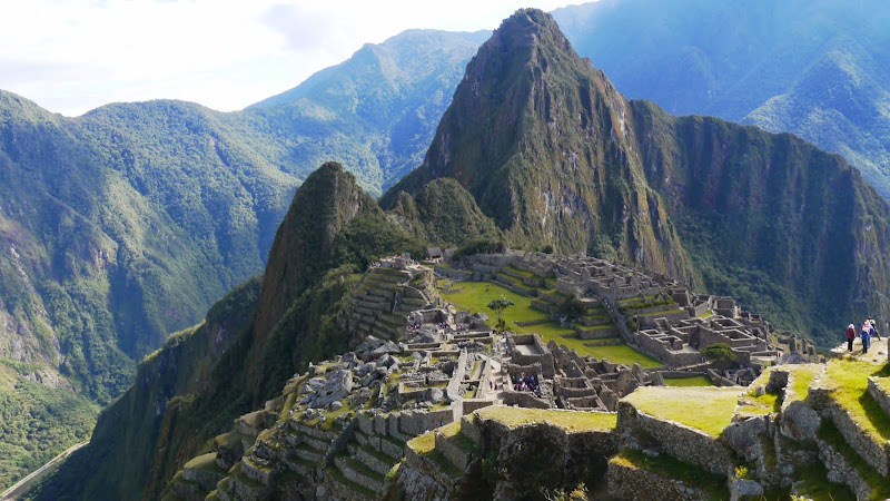
Machu Picchu Peak is the high mountain route above the Inca citadel, reached from RFG5+44F, Aguas Calientes 08680, Peru, in the Machu Picchu Historic Sanctuary’s upper archaeological zone. Part of the 15th-century imperial landscape associated with the Inca ruler Pachacuti, this demanding hike follows the official Circuit 1 panoramic route to Machupicchu Mountain. Travelers come for a bird’s-eye view of the citadel, the Urubamba River’s steep valley, Huayna Picchu, and the surrounding Vilcabamba mountains rather than for indoor exhibits.
What to Expect at Machu Picchu Peak
The mountain is accessed on Circuit 1, Route 1-A: Ruta Montaña Machupicchu, one of the routes introduced under Peru’s current circuit system. From the upper sector of the sanctuary, the signed stone-and-earth path climbs through high-elevation vegetation by a long sequence of steep Inca-style steps. The route is roughly 3.9 kilometres round trip and rises to about 3,082 metres above sea level, making acclimatization in Aguas Calientes or the Sacred Valley important before attempting it.
There is no museum collection or conventional exhibit trail here: the experience is the cultural landscape itself. Look down over the citadel’s agricultural terraces, the ordered roofs and stone walls of the urban sector, and the engineered contours that helped stabilize this exceptionally steep site. From the summit viewpoint, cloud cover can rapidly open and close across Huayna Picchu and the river gorge, so views depend on weather. Route 1-A is a panoramic ticket; it is not a substitute for a circuit that takes visitors through the principal urban monuments.
- Route 1-A, Machupicchu Mountain: the timed panoramic route specifically required for the peak hike.
- Summit elevation: approximately 3,082 metres, well above the citadel below.
- Stone stair ascent: a sustained uphill path with uneven steps, drop-offs, and little level ground.
- Citadel panorama: elevated views over terraces, the urban core, Huayna Picchu, and the Urubamba gorge.
- Upper agricultural sector: terraces and the classic upper viewpoints near the route’s approach.
Machu Picchu Peak at a Glance
| Detail | Information |
|---|---|
| Address | RFG5+44F, Aguas Calientes 08680, Peru |
| Neighborhood / Area | Machu Picchu Historic Sanctuary, upper archaeological zone above Aguas Calientes |
| Operating Hours | Daily, 7 AM–12 PM for the listed peak-entry window; timed admission applies. |
| Admission & Ticket Prices | Paid, timed Circuit 1 Route 1-A admission is required. Prices vary by visitor category and are published through the official Machupicchu channels. |
| Recommended Visit Duration | 2.5 to 3.5 hours for the mountain route, plus transport and sanctuary entry time. |
| Nearest Transit / Parking | Consettur bus stop at the Machu Picchu entrance; no visitor parking at the citadel. |
| Official Website / Phone | machupicchu.gob.pe / +51 984 016 565 |
Visiting Tips, Getting There & Nearby Pairings
Book the Machupicchu Mountain route before arranging trains and lodging: a general Machu Picchu ticket does not automatically include this climb. Choose the earliest available Route 1-A entry if you prefer cooler temperatures and need ample daylight for a measured ascent, then carry water, rain protection, sun protection, snacks, and footwear with grip. Rangers may regulate entry by the time printed on your ticket. Check the current route rules and availability on the official circuits page and confirm daily times on the official visiting-hours page.
Most visitors arrive by train at Machu Picchu Pueblo (Aguas Calientes), walk to Avenida Hermanos Ayar, and take the Consettur shuttle up to the sanctuary entrance; the bus journey takes about 25 to 30 minutes. Private cars cannot drive to or park at the citadel. The peak route has no elevator, paved wheelchair route, or stroller-friendly alternative: it involves many narrow, irregular steps and substantial ascent. Within roughly 5 to 15 minutes on permitted upper-sector paths, pair the hike with the Guardian’s House viewpoint, the upper agricultural terraces, and the entrance-area panorama over the citadel. There are no restaurants on the mountain trail, so eat in Aguas Calientes before boarding the bus.
Frequently Asked Questions
What are the hours and best time to visit Machu Picchu Peak?
The listed mountain-entry hours are 7 AM to 12 PM daily. An early timed entry gives hikers more time for the ascent and descent before afternoon weather becomes more likely; visibility can still change quickly at any hour.
Do I need a separate ticket, and what does it cost?
Yes. Reserve the paid Circuit 1, Route 1-A: Ruta Montaña Machupicchu ticket, which is the route that includes the peak. Current fares vary by visitor category, and the official website should be used to confirm prices, dates, entry times, and availability before purchase.
How much time should I budget for the hike?
Allow 2.5 to 3.5 hours for the 3.9-kilometre round-trip mountain route, longer if you are acclimatizing, stopping frequently for photographs, or hiking in wet conditions. Add the bus ride and time needed to reach the sanctuary entrance.
Is Machu Picchu Peak suitable for families or wheelchair users?
It suits fit older children and adults who are comfortable with sustained uphill walking, but it is not accessible for wheelchairs or strollers. The route has steep, uneven stairs, exposed edges, and no lifts; travelers needing step-free access should select a different Machu Picchu visit plan.
When planning your Machu Picchu travel guide or browsing verified attractions in Machu Picchu, pair this stop with standout local spots including ECO QUECHUA LODGES PERU, Hatun Inti Boutique Machupicchu, CAMINO A MACHU PICCHU, and National Archaeological Park Of Machu Picchu (0.8 km away).