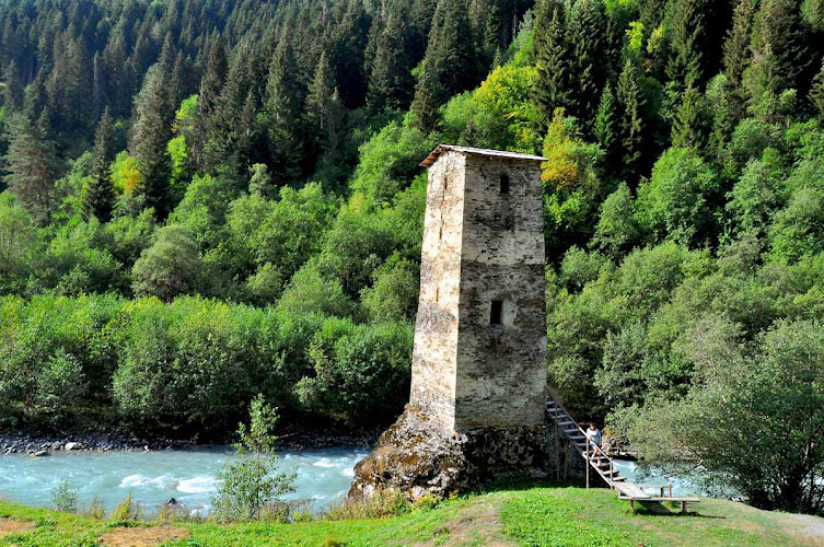
Racha-Lechkhum-Kvemo Svaneti Planned National Park is a high-Caucasus mountain landscape reached from the Zugdidi–Jvari–Mestia–Lasdili road at Ushguli, 3214, Georgia, in the historic Upper Svaneti area. Rather than a fenced, ticketed park with a visitor centre, it is a proposed protected-landscape destination of rugged ridges, forested slopes, alpine streams and lake country; travelers come to hike, photograph the Greater Caucasus and use Ushguli as a base for the Shkhara valley.
What to Expect at Racha-Lechkhum-Kvemo Svaneti Planned National Park
The experience here is defined by altitude, weather and self-guided exploration. Ushguli sits at roughly 2,100 metres, among Europe’s highest permanently inhabited settlements, with the snowbound wall of the Greater Caucasus immediately north. The classic outing follows the valley toward Shkhara Glacier, beneath Mount Shkhara at 5,193 metres, Georgia’s highest peak. Expect unpaved tracks, grazing cattle and horses, river crossings on established routes, and long views that change rapidly when cloud moves through the valley.
The surrounding region joins the cultural landscape of Upper Svaneti with remote alpine terrain. Ushguli’s four villages—Zhibiani, Chvibiani, Chajashi and Murqmeli—are distinguished by defensive Svan towers, stone houses and medieval churches; Chajashi forms part of the UNESCO-listed Upper Svaneti ensemble. This is not a managed trail network with marked loops, food kiosks or reliable indoor facilities. Carry water, layers, sun protection and offline mapping, and hire a local guide for glacier approaches, uncertain weather or routes beyond the well-used Shkhara valley track.
- Shkhara Glacier valley: The principal day hike from Ushguli follows the Inguri headwaters toward views of Georgia’s highest mountain and the glacier below it.
- Medieval Svan towers: Stone defensive towers rise throughout Ushguli, giving the approach and village walks their distinctive architectural character.
- Lamaria Church: The small hilltop Church of the Assumption above Zhibiani frames one of the area’s best close-range views of Ushguli and Shkhara.
- High-alpine terrain: Expect open meadows, fast streams, scree slopes and snow lingering on high ground well into summer.
- Chajashi village: A short walk through the western part of Ushguli reaches the dense historic quarter associated with the Upper Svaneti World Heritage landscape.
Racha-Lechkhum-Kvemo Svaneti Planned National Park at a Glance
| Detail | Information |
|---|---|
| Address | 3214 Zugdidi–Jvari–Mestia–Lasdili Road, Ushguli, Georgia |
| Neighborhood / Area | Upper Svaneti, Mestia Municipality, Samegrelo-Zemo Svaneti region |
| Operating Hours | Open landscape with no gate; visit in daylight and check road and weather conditions before departure. |
| Admission / Price Range | Free access to the landscape; guide, transport, food and accommodation are separate costs. |
| Recommended Visit Duration | Half day for village viewpoints; a full day for the Shkhara valley hike. |
| Nearest Transit / Parking | Mestia–Ushguli shared vans and 4WD taxis are the practical public-transport connection in season; informal roadside parking is available in Ushguli. |
| Official Website & Phone | Georgia Agency of Protected Areas; +995 591 81 23 71 |
Visiting Tips, Getting There & Nearby Pairings
Start early, particularly for the Shkhara valley, when mountain light is clear and afternoon rain or thunderstorms are less likely. The road from Mestia to Ushguli is rough in places and conditions can change after rain; a high-clearance vehicle or experienced local driver is the sensible choice. Seasonal shared vans from Mestia are useful when running, but departures are limited, so arrange return transport before setting out. There is no formal parking garage: use designated or clearly established spaces in the village without blocking homes, tracks or livestock movement.
Accessibility is limited by uneven cobbles, steep grassy paths, mud and unpaved vehicle tracks. The road through parts of Ushguli can bring visitors near the towers and Lamaria viewpoint, but the Shkhara route is not suitable for wheelchairs or standard strollers, and there are no dependable step-free restrooms or lifts in the landscape. Pair a park outing with Chajashi’s tower-lined lanes, Lamaria Church and the Ushguli ethnographic setting, all within a 5–15 minute walk of the village centre. For meals and supplies, use Ushguli’s small guesthouses and family-run cafés; selection is modest, so carry snacks for long hikes.
Frequently Asked Questions
What are the hours and best time to visit?
There are no gate hours because this is an open mountain landscape. Visit during daylight, ideally from early morning through early afternoon, and reserve extra time to return before weather deteriorates. The main hiking season is generally late spring through early autumn, while snow can restrict access in winter.
Is there an entrance fee or do I need a reservation?
There is no standard admission ticket for access to the Ushguli landscape or the Shkhara valley track. No reservation is required for independent walking, although transport, guides and overnight stays should be arranged ahead during the summer peak.
How much time should I budget?
Allow two to three hours for Ushguli’s towers, Lamaria Church and village viewpoints. Set aside a full day for the out-and-back Shkhara valley walk, including photo stops, changing conditions and the return journey to Mestia if you are not staying overnight.
Is the area suitable for families and visitors with limited mobility?
Active families can enjoy short village walks and roadside viewpoints, provided children are closely supervised around streams, traffic and livestock. Mobility access is challenging: historic lanes are rough and steep, while the longer valley trail has uneven ground and no step-free visitor infrastructure.
When planning your Svaneti travel guide or comparing verified attractions and national park in Svaneti, pair this stop with standout local spots including Vichnashi, Odo’s Winery – ოდოს მეღვინეობა, Mountain Mestia, and Zagari Pass (17.6 km away).