
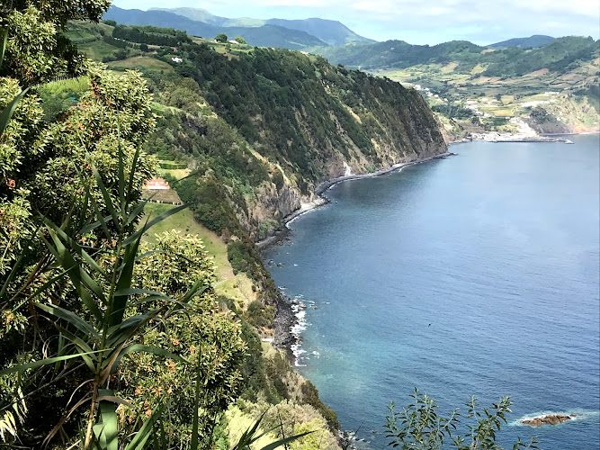
Agrião Trail, officially PR12SMI Trilho do Agrião, is a 7.1-kilometre linear walking route in the rural Furnas–Ribeira Quente area of São Miguel, Azores, Portugal. With no numbered street address, its signed access is reached on São Miguel’s southeast side; hikers come for three hours of green volcanic scenery, changing valley-and-coast views, and a more immersive alternative to the island’s roadside lookouts.
What to Expect at Agrião Trail
This is an officially designated medium-difficulty trail rather than a paved promenade. The 7.1-kilometre one-way format is important: arrange a pickup, use two vehicles, or confirm local transport before setting out rather than assuming a loop will return you to your starting point. Wayfinding follows the PR12SMI route, and the official Azores Trails page provides a map, downloadable GPS track, Google Earth file, and trail leaflet; download these while you have mobile signal.
Expect São Miguel at close range: humid Atlantic vegetation, volcanic terrain and broad openings toward the island’s rugged southeast landscape. “Agrião” is Portuguese for watercress, a fitting name for a route in a wet, green part of the island. Conditions can change quickly after rain, when earth paths and stone sections become slick. This is a hike for sturdy closed shoes, water, a light waterproof layer, and an unhurried pace rather than for a quick viewpoint stop.
- PR12SMI route: An official, signed São Miguel trail with map, GPS-track and leaflet downloads on the Azores Trails website.
- Linear 7.1-kilometre format: Plan transport at both ends; the published distance is not a return walk.
- Medium difficulty: The route’s three-hour average reflects uneven natural surfaces and the need for sensible pacing.
- Volcanic island terrain: Dense, moisture-loving greenery and exposed viewpoints show the contrast that defines São Miguel hiking.
- Self-guided experience: Walk independently with offline navigation, leaving time for weather, photographs and short rests.
Agrião Trail at a Glance
| Detail | Information |
|---|---|
| Address | PR12SMI Trilho do Agrião, São Miguel, Azores, Portugal; a rural route without a numbered street address. |
| Neighborhood / Area | Southeast São Miguel, in the Furnas–Ribeira Quente area. |
| Operating Hours | Open 24 hours daily; walk only in safe daylight and suitable weather. |
| Admission / Price Range | Free access; no trail admission charge. |
| Recommended Visit Duration | About 3 hours for the published route, plus transport time. |
| Nearest Transit / Parking | A car or pre-arranged taxi is the practical option; use designated or legal roadside spaces near signed access points and never block local roads. |
| Official Website & Phone | Azores Trails: PR12SMI Agrião; no dedicated trail phone is published. |
Visiting Tips, Getting There & Nearby Pairings
Start in the morning, particularly in warmer months, to allow for a slow finish and transport logistics before late afternoon. Check the official trail page on the day: rain, wind and ground conditions affect both footing and visibility. There is no ticket office, café, drinking-water point or guaranteed restroom service on the route, so stock up before leaving the Furnas or Ribeira Quente side. Keep gates closed, stay on the marked trail, and do not enter cultivated land or private paths.
There is no step-free, wheelchair-suitable route through this natural trail: uneven ground, gradients and potentially muddy surfaces demand stable mobility and hiking footwear. Families with confident older children can enjoy it with close supervision, but strollers are unsuitable. For a gentler nearby contrast, pair the walk with Ribeira Quente village and Praia do Fogo, the small black-sand beach on the south coast; Furnas village, its geothermal landscape and the gardens of Parque Terra Nostra make rewarding before- or after-hike stops reached by road rather than on foot.
Frequently Asked Questions
When is Agrião Trail open, and what is the best time to walk it?
The route is listed as open 24 hours daily, but daylight is the appropriate and safer time for a self-guided rural hike. Begin early for cooler temperatures, clearer light and enough margin for weather changes or a slower-than-expected finish.
Does Agrião Trail require tickets or reservations?
No admission ticket or reservation is required; access is free. The essential preparation is transport for a linear route and an offline copy of the official GPS track or map.
How much time should I allow for PR12SMI?
Allow about three hours for the published 7.1-kilometre route. Add time for photographs, rest breaks, changing weather and the drive or taxi transfer needed to manage the separate endpoints.
Is the Agrião Trail suitable for wheelchairs, strollers or young children?
No: this medium natural-surface trail is not step-free and is unsuitable for wheelchairs and strollers. It suits prepared walkers with secure footwear; children should be capable of completing a three-hour uneven-terrain hike and remain supervised.
When planning your Azores travel guide or browsing verified attractions in Azores, pair this stop with standout local spots including Sacred Art Center, Miradouro da Boca do Inferno, Cascata da Ribeira dos Caldeirões, and Octant Hotels Furnas (4.1 km away).


