Editorial disclosure: This destinations.ai guide was prepared with AI assistance and checked against the official sources linked below. Accommodation and activity placeholders may use affiliate links; that does not change the planning advice.
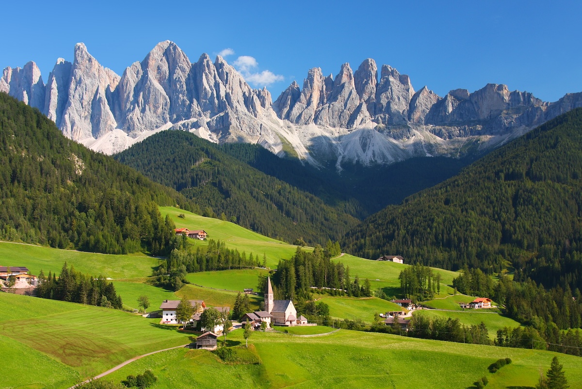
The Dolomites are a dramatic mountain range in northeastern Italy, a UNESCO World Heritage Site famed for jagged pale-rock peaks, emerald alpine lakes, and storybook valleys spanning Trentino-Alto Adige and Veneto.
Hike or take cable cars to icons like the Tre Cime di Lavaredo, photograph mirror-still Lago di Braies and Lago di Sorapis, and base yourself in scenic Val Gardena for access to Seceda and the Alpe di Siusi plateau. In winter the region becomes a world-class ski destination.
The best time for hiking is summer through early autumn, with September especially prized for warm, settled weather, thinner crowds, and the first golden larches into mid-October. Note new 2026 access rules: Lago di Braies has timed-entry restrictions in peak summer and Rifugio Auronzo requires a parking reservation. Many lodgings require multi-night stays.
Affiliate placeholder: Compare accommodation options after checking the official property details, location, and cancellation terms.
Affiliate placeholder: Check current activity availability, meeting points, accessibility, and cancellation terms before reserving.
Sources and current planning links
Explore more destinations.ai travel guides when building a longer route.
How to plan a Dolomites visit
The Dolomites are a mountain region, not one town or one park, so the best itinerary begins with a valley, a base, and a season. Distances that look short on a map can involve winding roads, mountain passes, limited parking, lift schedules, and changing weather. Choose the landscape or activity you care about most, then build a realistic radius around it.
Choose a base that matches your route
Val Gardena, Cortina d’Ampezzo, Alta Badia, and other valleys offer different access to peaks, huts, lifts, and villages. A base near a lift can simplify a hiking or skiing holiday, while a larger town may provide more restaurants and transport. Compare the exact road, parking, grocery access, altitude, room facilities, and minimum-stay rules before booking.
Mountain huts can be the destination as well as a place to eat or sleep, but availability is limited and conditions affect access. Reserve where required, confirm arrival times and luggage arrangements, and carry enough water and clothing for a weather change. Never assume that a hut or cable car shown in a summer article operates on a winter or shoulder-season schedule.
Plan the iconic walks honestly
Tre Cime di Lavaredo, Lago di Braies, Seceda, and Alpe di Siusi are popular because the scenery is extraordinary, but popularity creates access pressure. Check current parking reservations, shuttle requirements, timed entry, lift operations, trail closures, and weather before leaving your lodging. Arrive early when a site has limited parking, and keep a second route in the same valley in case the main one is full.
Choose a hike by elevation gain, surface, exposure, technical requirements, and return time—not by a photograph or a headline distance. Via ferrata routes require appropriate equipment, experience, and current conditions; they are not simply scenic trails with ladders. Families and less experienced walkers can enjoy a lift-accessed viewpoint, meadow path, lake walk, or short valley trail just as meaningfully.
Decide between summer, autumn, and winter
Summer is the main hiking season, autumn can bring clear days and changing larch color, and winter shifts the region toward skiing, snowshoeing, and mountain hospitality. Spring is a transition period at elevation; some lifts, trails, and huts may be closed while lower valleys are already green. Check the exact operating calendar and forecast for the valley you will visit.
Mountain weather can change quickly in every season. Carry layers, sun protection, water, a charged phone, and footwear appropriate to the surface. Check avalanche, thunderstorm, wildfire, road, and air-quality information when relevant. If the forecast is poor, substitute a village, museum, food stop, scenic drive, or lower-elevation walk rather than forcing a high route.
Getting around the Dolomites
A car provides the most flexibility between valleys, but public buses, lifts, shuttles, and guided tours can be better on crowded or narrow routes. Verify whether a road is open, whether parking needs a reservation, and how long a pass or transfer really takes. Do not plan three distant viewpoints around a timed dinner; mountain traffic and weather deserve a margin.
Food is a reason to slow down. Look for current farm restaurants, mountain huts, bakeries, and regional menus along the route, then confirm service hours and reservations. Ask about allergies and dietary needs in advance, especially at smaller huts. For accessibility, discuss lift boarding, trail surface, toilets, parking, and seating with the specific operator; mountain access varies considerably.
A practical four-day Dolomites itinerary
- Day one: Arrive at a single valley base, check the forecast and lift schedule, and take a short village or meadow walk.
- Day two: Follow one confirmed signature route such as a lake, viewpoint, or lift-accessed trail, allowing time for parking and a weather change.
- Day three: Choose a different landscape or activity—hut meal, cycling, via ferrata with qualified support, or a lower route suited to the group.
- Day four: Keep the final day flexible for a second viewpoint, regional village, scenic drive, or an early departure.
The Dolomites reward repeat visits because each valley has its own character. A focused itinerary with fewer transfers protects the landscape, your energy, and the quality of the experience.
Dolomites planning tips for different travelers
Families and first-time hikers should choose a valley walk, lift-accessed viewpoint, or short lake route before attempting a signature high trail. Experienced walkers can plan longer routes or a qualified via ferrata, while non-hikers may prefer a village, hut meal, scenic lift, or cultural stop. Everyone should know the return route, the last lift or bus, and the nearest weather shelter before setting off.
Do not make the most exposed activity the day after a long arrival drive. Use the first evening to buy water and food, check the forecast, confirm parking or shuttle details, and ask your accommodation about local conditions. If a pass is closed or a storm is building, a lower-elevation route is a thoughtful change of plan, not a failed holiday.
Travelers without a car should choose a base with dependable bus and lift connections and ask how early the first service runs. Drivers should check restricted roads, tolls, parking reservations, and winter equipment requirements. In every case, download or save the route, carry a charged phone, and do not rely on a single photo stop or a last evening bus to make the itinerary work.
Arrival and departure days need extra restraint. Mountain roads, weather, and luggage make a timed transfer more fragile than a city train. Keep the last walk close to the base, return equipment on time, and allow a generous buffer before an airport or long-distance connection. The region’s scale becomes an advantage when you focus on one valley and return with energy left to enjoy it.
Before each mountain day, ask the local tourist office or accommodation about current trail, lift, road, and weather conditions. Save the last return option and tell someone your route if you are leaving the busy valley. A scenic plan that can be shortened safely is better than one that depends on perfect visibility, an open pass, and an exact arrival time at a distant restaurant.
Photography stops also need judgment. Pull fully into designated parking, never block a mountain road, and do not leave a marked trail for a better angle. In a protected landscape, the quietest and safest viewpoint is often the more memorable one. Let the route’s limits guide the day, especially when snow, ice, rockfall, or thunderstorms make a popular landmark harder to reach.
When choosing between two attractive valleys, favor the one with the better fit for your dates and ability rather than trying to visit both in a single afternoon. Ask about local buses, lift queues, trail etiquette, and where to refill water. That decision keeps the Dolomites trip grounded in the actual conditions of the day.
What to confirm before a Dolomites departure
Confirm access, weather, transport, and the last return option on the day of each outing. Mountain plans change quickly, and a current local notice is more useful than a fixed itinerary written months earlier. Keep the official contact for the lift, park, hut, or shuttle with your route and change plans early when conditions require it.
For a longer regional route, compare Venice, Italy, Milan, Italy, Innsbruck, Austria with this destination before finalizing your itinerary.
Frequently asked questions
What is Dolomites, Italy best known for?
The Dolomites are a dramatic mountain range in northeastern Italy, a UNESCO World Heritage Site famed for jagged pale-rock peaks, emerald alpine lakes, and storybook valleys spanning Trentino-Alto Adige and Veneto.
When is the best time to visit Dolomites?
In winter the region becomes a world-class ski destination.
How many days should you spend in Dolomites?
Plan about 3 days for a first visit, then add time if you want to explore beyond the central sights.
How should you get around Dolomites?
Note new 2026 access rules: Lago di Braies has timed-entry restrictions in peak summer and Rifugio Auronzo requires a parking reservation.
What should you book ahead in Dolomites?
The Dolomites are a dramatic mountain range in northeastern Italy, a UNESCO World Heritage Site famed for jagged pale-rock peaks, emerald alpine lakes, and storybook valleys spanning Trentino-Alto Adige and Veneto.
Explore Dolomites by Category: Discover top curated spots across Dolomites Attractions & Sightseeing, Best Places to Stay in Dolomites, Dolomites Restaurants & Dining.