Putucusi is a steep, forested mountain above the Urubamba River at 08680, Peru, opposite Machu Picchu in the Machu Picchu Pueblo (Aguas Calientes) area. Long valued for its unusual, head-on view across the valley toward the Inca citadel, it became known for a demanding ladder-and-stair ascent; today, its damaged route and exposed terrain make it a place to understand from safe public viewpoints rather than a routine add-on to a Machu Picchu visit.
What to Expect at Putucusi
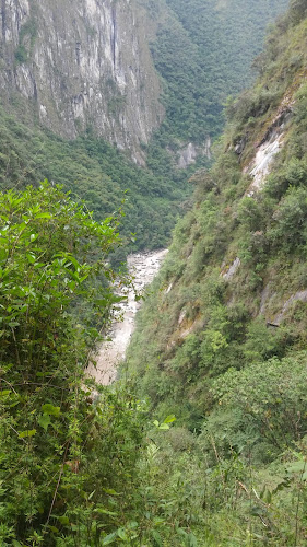
Putucusi rises on the northeast side of the river, facing Machu Picchu’s eastern slopes and the iconic profile of Huayna Picchu. In clear weather, the mountain’s former summit viewpoint framed the citadel from outside the archaeological complex: agricultural terraces, stone structures and the surrounding ridgelines appear across a deep, humid valley. This is not an Inca site with galleries, a visitor center, marked exhibits or facilities; it is rugged cloud-forest terrain beside the rail corridor serving Machu Picchu Pueblo.
The historic route was notable for near-vertical wooden ladders, fixed cables, muddy stone steps and a sharp climb through dense vegetation. Heavy rain damaged the ladders, and the traditional ascent is not a maintained public trail. Do not treat old online hiking accounts as current route instructions, attempt makeshift ladders, or walk on railway tracks. The safer way to appreciate Putucusi is to view its rounded, cliff-edged form from Machu Picchu Pueblo and reserve your energy for authorized routes within the sanctuary.
- Opposite-valley perspective: Putucusi faces Machu Picchu across the Urubamba River, creating the broad contextual view that the citadel’s internal circuits cannot provide.
- Former ladder route: The mountain became famous for timber ladders and cables on exceptionally steep sections; these structures are not a substitute for a maintained trail.
- Cloud-forest setting: Ferns, mossy vegetation and frequent mist define the humid slope, especially in the rainy season from roughly November through March.
- Huayna Picchu profile: From the wider valley, Putucusi helps explain the dramatic relationship between Machu Picchu, Huayna Picchu and the river gorge.
- Aguas Calientes base: Machu Picchu Pueblo supplies trains, hotels, restaurants and the official bus departure area for visitors continuing to Machu Picchu.
Putucusi at a Glance
| Detail | Information |
|---|---|
| Address | Putucusi Mountain area, 08680, Peru |
| Neighborhood / Area | Machu Picchu Pueblo (Aguas Calientes), Urubamba Valley, Cusco Region |
| Operating Hours | No staffed visitor hours; the former ascent is not a maintained public route |
| Admission / Price Range | No separate ticket price; no current public ticketing system for the ascent |
| Recommended Visit Duration | 20 to 40 minutes for safe valley viewing and orientation in town |
| Nearest Transit / Parking | Machu Picchu Pueblo rail station; Aguas Calientes is car-free, with no visitor parking at Putucusi |
| Official Website & Phone | Peru Ministry of Culture; no dedicated Putucusi phone line |
Visiting Tips, Getting There & Nearby Pairings
Arrive in Machu Picchu Pueblo on an early train if you want the best chance of clearer mountain views before afternoon cloud cover gathers in the gorge. The Machu Picchu Pueblo rail station is the practical transit hub; the town has no road connection for private visitor cars. Wear grippy footwear and carry rain protection even for riverside walks, but do not enter closed or unstable trail infrastructure. For a formal high-elevation hike, book the appropriate Machu Picchu or Huayna Picchu entry in advance through authorized channels.
Putucusi has no step-free trail, toilets, benches, railings, elevators or staffed rescue point. The former route’s ladders, slick ground and sustained steepness make it unsuitable for wheelchairs, strollers, young children and travelers uncomfortable with heights. In town, pair an outward view of the mountain with the Mariposario of Machu Picchu, about 0.6 kilometers away, or explore the riverside streets and Mercado Artesanal near the rail station. The official bus departure point for Machu Picchu is also within an easy walk of central Aguas Calientes.
Frequently Asked Questions
What are Putucusi’s hours, and when is the best time to see it?
Putucusi has no ticket office or published operating schedule because it is a mountain rather than a managed attraction. View the slope from public areas around Machu Picchu Pueblo early in the day, when visibility is often better and rain is less likely than later in the afternoon.
Does Putucusi require a ticket or reservation?
There is no separate Putucusi admission ticket or reservation system. The lack of a ticket does not mean the former ladder route is open or safe; choose authorized sanctuary circuits if hiking is part of your plan.
How much time should I budget for Putucusi?
Allow 20 to 40 minutes to orient yourself to the mountain and take safe valley photographs from Machu Picchu Pueblo. Do not build a Machu Picchu day around climbing Putucusi, as the historic ascent is not a maintained visitor experience.
Is Putucusi suitable for families or travelers with limited mobility?
No. Its former route involved exposed ladders and steep, muddy forest ground, with no accessible facilities or step-free alternative; families and mobility-limited visitors should enjoy the mountain as part of the valley scenery instead.
When planning your Machu Picchu travel guide or browsing verified attractions in Machu Picchu, pair this stop with standout local spots including Ayar Manco, POQUES, Full House Peruvian cuisine &craft beer, and Phutuq K'usi (0.2 km away).