
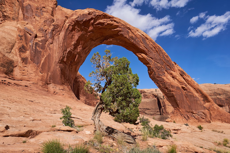
Corona Arch is a 140-foot-wide Entrada Sandstone arch on Bureau of Land Management land along Utah State Route 279 (the Potash Road), about 10 miles northwest of downtown Moab, Utah 84532. The moderately strenuous 3-mile round-trip hike was designated a National Recreation Trail on May 30, 2018, and it ends beneath one of the largest spans in the Moab area, with Bowtie Arch tucked into the same alcove along the way.
What to Expect at Corona Arch
The trail starts at a signed parking area on the north side of the highway. It climbs a short bench of slickrock to a visitor register box beside the Union Pacific railroad line, where hikers are asked to sign in. After crossing the tracks, the route follows an old roadbed up through a gap in the canyon rim, then picks up rock cairns that lead up a wash. Look for the white paint blazes and cairns on the slickrock above, since the path is not a continuous dirt tread. A few short sections have mild exposure, and the BLM has installed steel cables and a ladder so hikers can steady themselves on the steeper ledges.
The payoff is the arch itself, a wide red span that frames sky and canyon wall in a way that suits wide-angle photography. The arch earned a second kind of fame after rope swings and a famous aircraft flight through the opening drew national attention, so expect to see signs reminding visitors that any rigging activity requires BLM authorization. The hike gains roughly 450 feet in elevation, and the exposed slickrock makes it a different experience in July than in October.
- Corona Arch: A massive Entrada Sandstone span roughly 140 feet wide, the destination of the trail and its main photo subject.
- Bowtie Arch: A pothole arch, a hole worn through a ledge, passed shortly before the main arch and easy to miss without looking up.
- Cables and ladder sections: Short assisted ledge climbs where steel handlines make the route manageable for most reasonably fit hikers.
- Railroad crossing: The trail crosses an active Union Pacific line, so stop, look, and listen before stepping across the tracks.
- Colorado River corridor views: The approach and return look over Highway 279 and the river canyon, with Moab Rim walls on the horizon.
Corona Arch at a Glance
| Detail | Information |
|---|---|
| Address | Potash Road (Utah SR-279), Moab, UT 84532 |
| Neighborhood / Area | Colorado River corridor, northwest of Moab, near Gold Bar Rim |
| Operating Hours | Open 24 hours daily; daylight hiking strongly recommended |
| Admission / Price Range | Free; no fee or permit for day hiking |
| Recommended Visit Duration | 1.5 to 3 hours round trip, plus photo time |
| Nearest Transit / Parking | No public transit; free trailhead parking lot on the north side of SR-279 |
| Official Website & Phone | blm.gov/visit/corona-arch-trail; contact the BLM Moab Field Office through the BLM site |
Visiting Tips, Getting There & Nearby Pairings
The trailhead is reached by driving about 10 miles from Moab by way of US-191 north to SR-279, then following the Colorado River along the Potash Road until the signed parking area. There is no shuttle or public transit, so a personal vehicle or rental car is essential. The lot fills by mid-morning in spring and fall, so an arrival close to sunrise gives you quiet slickrock and softer light on the red rock, while late afternoon works well for glowing canyon walls. Carry at least a liter of water per person, wear shoes with good grip for slickrock, and register at the box before crossing the tracks.
The trail is not step-free. It involves uneven slickrock, a ladder, and handline sections, which makes it unsuitable for wheelchairs and difficult for strollers. After the hike, the Potash Road continues past Jug Handle Arch and the Poison Spider Mesa trailhead, and the Moab Giants area and Main Street dining are about a 20-minute drive back toward town. Mid-summer afternoons can exceed 100 degrees Fahrenheit on bare rock, so plan accordingly.
Frequently Asked Questions
What are the hours and best time to visit Corona Arch?
The trail is open 24 hours a day, every day, but hiking is best in daylight. Early morning and late afternoon offer the best light and cooler temperatures, and spring and fall are the most comfortable seasons.
Does the Corona Arch hike cost money or require a permit?
Day hiking is free, with no entrance fee or permit required. Hikers are asked to sign the voluntary register at the railroad crossing so land managers can track use.
How long does the Corona Arch hike take?
The round trip is about 3 miles and takes most hikers 1.5 to 3 hours depending on pace and time spent photographing the arches. The terrain is moderately strenuous, with slickrock and some assisted ledges.
Is Corona Arch suitable for kids, dogs, and mobility needs?
Active school-age children can usually manage it with supervision near the exposed ledges and the railroad crossing. Dogs are allowed on a leash, though hot slickrock can burn paws, and the route is not accessible for wheelchairs or strollers.
When planning your Moab travel guide or comparing verified attractions and hiking area in Moab, pair this stop with standout local spots including The Spoke on Center, Moab Giants, Under Canvas Moab, and Jug Handle Arch (4.2 km away).


