Toro Park is a 4,756-acre Monterey County regional park at 501 Monterey-Salinas Highway 68, Salinas, CA 93908, in the Toro Park area of unincorporated Monterey County just west of Salinas, California, United States of America. Built around the oak woodland, seasonal drainages, grassland slopes, and former ranch landscape on the south side of Highway 68, it is a long-standing local destination for family picnics, youth sports, horseback riding, mountain biking, and demanding hikes to broad Salinas Valley viewpoints.
What to Expect at Toro Park
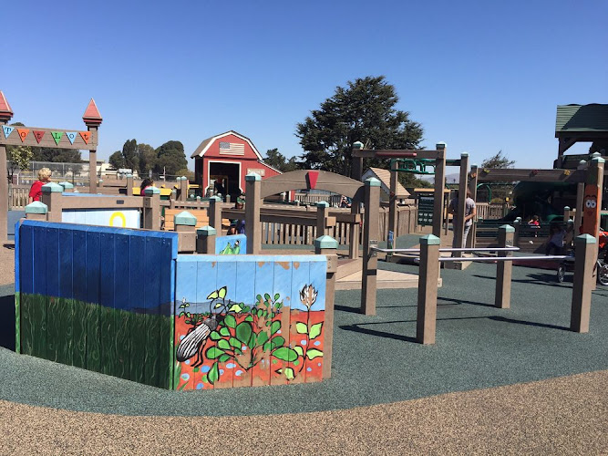
The lower, developed park is the social center: mature oaks and eucalyptus shade picnic lawns, group-use areas, playgrounds, softball fields, volleyball courts, and horseshoe pits. This is not a museum or a landscaped garden with formal exhibits; its main attraction is room to gather before heading into a much larger backcountry landscape. Group picnic areas are popular for reunions and celebrations, while the open fields make the park a practical stop for families looking to combine a short walk with play time.
Beyond the day-use core, roughly 20 miles of multi-use trails climb through coast live oak woodland and open ridges. The signature objective is Ollason Peak, reached by a sustained, exposed uphill route and known for views across the Salinas Valley toward the Gabilan Range and, on clear days, Monterey Bay. Expect natural dirt trails rather than a groomed urban path: grades can be steep, summer heat builds quickly on the hillsides, and hikers share the network with equestrians and mountain bikers. Spring brings green hills and wildflowers; by late summer the grass is gold and shade is limited away from the lower park.
- Ollason Peak: A strenuous ridge-and-summit outing with expansive valley and coastal views in clear weather.
- Multi-use trail network: About 20 miles of routes for hiking, horseback riding, and mountain biking.
- Oak-shaded picnic grounds: Developed day-use spaces with reservable group areas for gatherings.
- Family recreation: Playgrounds, softball fields, volleyball courts, and horseshoe pits in the lower park.
- Seasonal landscape: Green, flower-speckled hills in spring and dry, open golden slopes in late summer and fall.
Toro Park at a Glance
| Detail | Information |
|---|---|
| Address | 501 Monterey-Salinas Highway 68, Salinas, CA 93908 |
| Neighborhood / Area | Toro Park area, unincorporated Monterey County; west of Salinas along Highway 68 |
| Operating Hours | Daily, generally 8 AM–5 PM; gate hours can change seasonally |
| Admission & Ticket Prices | Paid vehicle day-use entry; check the county’s current fee schedule and reservation details before departure |
| Recommended Visit Duration | 1.5–2.5 hours for the developed park; allow 3–5 hours for a peak hike |
| Nearest Transit / Parking | No regular public-transit stop at the park; on-site day-use parking is reached from Highway 68 |
| Official Website / Phone | Monterey County Parks / 831-755-4895 |
Visiting Tips, Getting There & Nearby Pairings
Arrive near opening time on weekends, especially in spring, when ballgames and reserved picnics can fill the lower lots. A weekday morning is best for a quieter trail start. Pay the vehicle day-use fee at entry and reserve group picnic facilities through Monterey County Parks well ahead of a weekend event; ordinary hiking does not require a timed ticket. Bring more water than you expect to use, sun protection, sturdy shoes, and a downloaded map or screenshot of your route. Stay alert for poison oak, ticks, and rattlesnakes, and yield calmly to horses by stepping off the trail on the downhill side when directed by the rider.
Driving is the practical way to reach Toro Park: there is no regular bus stop at the entrance, and Highway 68 traffic can be fast. The lower recreation area is the most workable choice for strollers and visitors with limited mobility, with parking close to picnic and play facilities; backcountry routes, including the Ollason Peak climb, are unpaved, steep, uneven, and not wheelchair accessible. The park is relatively isolated, so there are no restaurants or major visitor landmarks within a 5–15 minute walk. For a driving-day pairing, consider Fort Ord National Monument west along Highway 68, WeatherTech Raceway Laguna Seca, or family-focused Tatum’s Garden in Salinas.
Frequently Asked Questions
What are Toro Park’s hours, and when is the best time to go?
The park generally operates daily from 8 AM to 5 PM, though gate hours can vary by season. Go early for cooler temperatures and easier parking; March through May is especially appealing for green hills and wildflowers.
Does Toro Park charge admission or require reservations?
There is a paid vehicle day-use entry fee. Check the official Monterey County Parks page for current rates. Reserve a group picnic area in advance; hikers using general day-use areas do not need a timed reservation.
How much time should I budget for Toro Park?
Plan 90 minutes to 2.5 hours for a picnic, playground visit, and short walk. Allow at least 3 to 5 hours for Ollason Peak or a longer multi-use trail loop, including rest, water, and the return descent.
Is Toro Park good for families and wheelchair users?
Yes for families using the lower park’s playgrounds, fields, and picnic areas. Visitors using wheelchairs or strollers should remain in the developed lower area, as the hillside trail system has natural surfaces, steep grades, and uneven terrain.
When planning your Salinas travel guide or comparing verified attractions and parks in Salinas, pair this stop with standout local spots including Tatum's Garden, Monterey Zoo, Pastability's, and Creekside Terrace Trailhead, Fort Ord National Monument, California (2.3 km away).