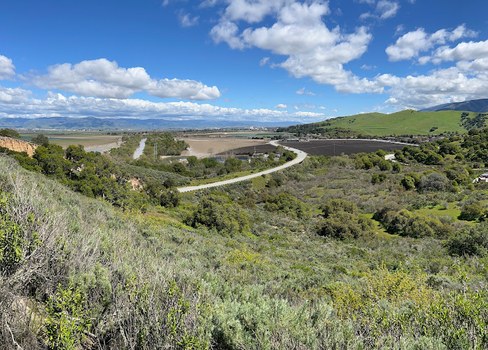
Creekside Terrace Trailhead is a neighborhood-edge access point on Creekside Terrace, Salinas, CA 93908, leading into Fort Ord National Monument’s former military landscape of grassland, maritime chaparral and oak woodland. Fort Ord was an active U.S. Army installation from 1917 to 1994 and became a national monument in 2012; travelers come here to hike, mountain-bike or ride horseback through an unusually large protected open-space network near the Salinas Valley.
What to Expect at Creekside Terrace Trailhead
This is a simple trail access rather than a developed park entrance or visitor center. From Creekside Terrace, routes connect with Fort Ord National Monument’s more than 86 miles of designated trails, which cross rolling former Army training grounds and preserve habitats including streamside corridors, grasslands, maritime chaparral, oak woodlands and seasonal pools. Expect exposed stretches, dry summer conditions and broad views across the inland Monterey County hills rather than redwood forest.
The monument’s distinctive value is the combination of recreation and recovery: land once used for military training is now protected for public access and sensitive native habitat. Hikers share portions of the system with mountain bikers and equestrians, so keep right, announce passes and yield appropriately. Spring brings wildflower color and greener hills; summer and fall are typically warm and dusty, while winter rain can leave natural-surface trails muddy or temporarily affected by closures.
- 86-mile trail network: Fort Ord National Monument provides over 86 miles of routes for hiking, cycling and horseback riding.
- Maritime chaparral: Look for the dense, low-growing coastal shrub community that is one of the monument’s defining habitats.
- Oak woodland and grassland: Rolling open slopes and oak-dotted sections create changing shade, exposure and long sightlines.
- Former Fort Ord landscape: The trails pass through land associated with the Army post that operated from 1917 until 1994.
- Wildlife watching: Quiet early outings can reveal birds and other wildlife; stay on signed routes to protect habitat and seasonal pools.
Creekside Terrace Trailhead at a Glance
| Detail | Information |
|---|---|
| Address | Creekside Terrace, Salinas, CA 93908 |
| Neighborhood / Area | Southwest Salinas / Fort Ord National Monument’s inland edge |
| Operating Hours | Daily, sunrise to sunset; check for weather, fire-safety or habitat-related trail notices before setting out. |
| Admission / Price Range | Free admission; no entrance fee. |
| Recommended Visit Duration | 1.5 to 2.5 hours for a short out-and-back or loop connection. |
| Nearest Transit / Parking | A car is the practical option. Monterey-Salinas Transit Route 23 runs along the Highway 68 corridor, but does not provide trailhead-front service; use only signed, legal parking around Creekside Terrace and never obstruct neighborhood access. |
| Official Website & Phone | BLM Fort Ord National Monument; 831-582-2200 |
Visiting Tips, Getting There & Nearby Pairings
Start near sunrise for cooler temperatures, clearer light and a better chance of seeing wildlife before bike traffic increases. Download or photograph a route map before leaving cell coverage, carry more water than you expect to need, and wear sun protection and grippy closed-toe shoes. There is no admission gate or staffed desk at this access point, so check the official BLM monument page for current alerts, trail conditions and permitted uses. Keep dogs leashed and pack out all waste.
Creekside Terrace Trailhead is best treated as an undeveloped, natural-surface access point: uneven ground, slopes, loose soil and narrow shared trails can be difficult for wheelchairs, many strollers and visitors with limited mobility. There is no visitor-center-style accessible route or indoor rest area here; plan a shorter out-and-back on the firmest available surface and turn around when conditions change. By car, Toro County Park is a useful nearby pairing for its creekside picnic setting, while WeatherTech Raceway Laguna Seca and Oldtown Salinas are roughly 5 to 15 minutes away depending on traffic.
Frequently Asked Questions
What are the hours, and when is the best time to go?
The monument is generally open daily from sunrise to sunset. Arrive early, especially from late spring through fall, for cooler hiking and less exposed midday heat; avoid trails during severe weather or posted fire restrictions.
Is there an entrance fee or a reservation requirement?
Access to Fort Ord National Monument is free, and Creekside Terrace Trailhead does not require a reservation. Check official BLM notices before travel, since individual routes may be affected by maintenance, habitat protection, weather or public-safety conditions.
How much time should I allow for this trailhead?
Allow 1.5 to 2.5 hours for a moderate exploration that includes an out-and-back or a connected loop. Strong hikers and mountain bikers can spend much longer linking into the monument’s extensive trail system, but should carry navigation, water and daylight margins.
Is Creekside Terrace Trailhead suitable for families and wheelchairs?
Families comfortable with unpaved open-space trails can enjoy short, supervised walks, particularly in mild morning weather. The natural terrain is not a dependable wheelchair or stroller route, and visitors should not expect developed restrooms, drinking water or a staffed facility at this trailhead.
When planning your Salinas travel guide or browsing verified hotels in Salinas, pair this stop with standout local spots including El Chilacatazo, Howard Johnson by Wyndham Salinas, El Charrito, and Toro Park (2.3 km away).