Editorial disclosure: This destinations.ai guide was prepared with AI assistance and checked against the official sources linked below. Accommodation and activity placeholders may use affiliate links; that does not change the planning advice.
Flagstaff, Arizona, sits at 7,000 feet in northern Arizona’s high country, where ponderosa pines, volcanic landscapes, railroad history, and clear night skies shape a very different Arizona trip. You can use the city as a Grand Canyon base, then spend equally rewarding time close to town at observatories, museums, trails, and national monuments.
This Flagstaff travel guide helps you plan a trip that balances downtown time, high-elevation outdoor recreation, and the major landscapes of the Colorado Plateau. Pack layers in every season, allow time to adjust to the altitude, and treat changing mountain weather as part of the itinerary.
Flagstaff works especially well when you want cooler summer conditions, winter snow sports, dark-sky programs, or a road-trip stop with substance beyond the Grand Canyon. Begin with the city’s visitor resources and build your days around weather, daylight, and timed-entry requirements.
Key Takeaways
- Flagstaff combines Route 66 character, astronomy, forests, and Indigenous history.
- A car gives you the greatest flexibility for national monuments and day trips.
- Summer and fall reward hikers, while winter suits snow play and skiing.
Quick Answers and Trip Profile
Flagstaff is a high-elevation mountain city in Coconino County, Arizona, United States, at coordinates 35.19003991, -111.6389465. You are about 80 miles south of Grand Canyon National Park’s South Rim and surrounded by Coconino National Forest, with the San Francisco Peaks rising north of downtown.
- Best for: Road trips, hiking, stargazing, skiing, family travel, Route 66 history, and Grand Canyon access.
- Ideal trip length: Two or three nights gives you time for Flagstaff plus one major nearby destination.
- Elevation: About 7,000 feet, so hydration, sunscreen, rest, and a slower first day help you acclimate.
- Closest airport: Flagstaff Pulliam Airport, with larger flight options available through Phoenix Sky Harbor International Airport.
- Best base: Downtown for walkability; west Flagstaff or the Highway 180 corridor for Snowbowl and Grand Canyon access.
You’ll find a compact historic core around Heritage Square, Northern Arizona University nearby, and major outdoor destinations a short drive away. For a useful orientation before booking, browse the destination overview for Flagstaff, Arizona alongside current local conditions.
Best Things to Do in Flagstaff, Arizona, United States
Flagstaff’s strongest attractions connect you with astronomy, volcanic geology, forest trails, and the city’s railroad-era downtown. Give Lowell Observatory an evening slot if possible, then reserve daylight for monuments or the San Francisco Peaks.
- Lowell Observatory: Visit the hilltop observatory associated with the discovery of Pluto and plan around public programs, telescope viewing, and changing weather. Flagstaff’s status as the world’s first International Dark Sky Community makes astronomy a central part of your visit, as highlighted by Flagstaff’s dark-sky designation.
- Walnut Canyon National Monument: Walk the Island Trail when conditions allow to see Sinagua cliff dwellings set into a limestone canyon. The steep route includes many stairs, so the rim trail offers a more accessible alternative.
- Sunset Crater Volcano National Monument: Explore the lava flows, cinder fields, and volcanic landscape created by an eruption roughly 1,000 years ago. Pair it with nearby Wupatki National Monument on the same driving day.
- Wupatki National Monument: Visit large ancestral Puebloan sites such as Wupatki Pueblo, where open grassland and red-rock formations create a sharp contrast with Flagstaff’s pine forest.
- Historic Downtown and Route 66: Walk Heritage Square, browse local shops, watch freight trains pass, and look for preserved Route 66 landmarks. Downtown is especially pleasant in the late afternoon, when you can combine museums, coffee, and dinner without moving the car.
- Arizona Snowbowl: Ride the scenic chairlift in the warm season or ski and snowboard during winter operations. Check lift schedules, parking details, and weather before leaving town.
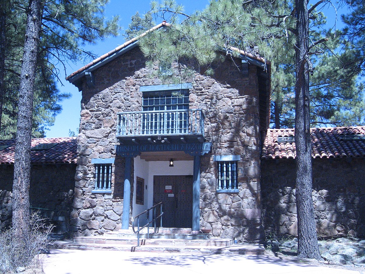
- Museum of Northern Arizona: Spend time with regional geology, Native arts, and cultural history before visiting archaeological sites. The Museum of Northern Arizona provides valuable context for the Colorado Plateau.
For changing seasonal activities, dining, and attraction listings, use the official guide to things to do in Flagstaff. Hours, trail access, and special programs shift through the year.
History, Culture, and Local Character
Flagstaff’s character comes from railroad development, Route 66, Northern Arizona University, astronomy, and the living cultures of the Colorado Plateau. Approach cultural sites with care: these landscapes hold deep significance for Indigenous communities and deserve more than a quick photo stop.
The region preserves evidence of ancestral Puebloan communities, including Sinagua sites at Walnut Canyon and major pueblos at Wupatki. Museum exhibits help you place architecture, pottery, farming, trade, and migration within a longer regional story.
Present-day Navajo, Hopi, Zuni, Havasupai, Apache, and other Indigenous peoples remain integral to northern Arizona. That continuing presence matters when you visit archaeological sites or interpret the region’s history.
Downtown Flagstaff developed around the railroad and later Route 66, leaving you with historic commercial blocks, old motor-court architecture, breweries, music venues, and a busy college-town rhythm. The original highway corridor also runs through the Southside, an area shaped by railroad employment and community histories.
Flagstaff’s lunar legacy adds another layer. Astronauts trained in the area’s volcanic terrain during the Apollo era, and regional mapping work helped prepare lunar missions. You can find current exhibits and visitor ideas through Flagstaff’s official tourism information.
Neighborhoods, Parks, and Outdoor Activities
Downtown is your best choice for a walkable stay, while Flagstaff’s surrounding forests and peaks deliver the outdoor access that defines the city. Choose trails according to altitude, storms, snow cover, and your group’s conditioning.
Downtown and Southside place you close to Heritage Square, restaurants, breweries, the train station, and Northern Arizona University. You can cover much of this area on foot, though rail crossings and winter ice call for extra attention.
West Flagstaff gives you easier access to Interstate 40, Highway 180, Snowbowl Road, and the Grand Canyon route. East Flagstaff works well for Walnut Canyon access and quieter lodging near Interstate 40.
- Buffalo Park: Use this city park for open views of the San Francisco Peaks and an easy walk close to town.
- Fut’s Knoll: Follow a short local hike for a broad overlook above downtown. Start early during warm weather and avoid exposed areas when lightning is nearby.
- Humphreys Peak: Take on Arizona’s highest summit only with strong fitness, sufficient water, warm layers, and a close weather check. Afternoon thunderstorms create serious risk on high ridges.
- Fatman’s Loop: Choose this short trail near town for a manageable introduction to Flagstaff’s pine forest and rock formations.
- Mountain biking and forest roads: Ride designated routes and confirm current closures before heading out. Fire restrictions and monsoon damage affect access.
Flagstaff is surrounded by public land, so responsible recreation protects the experience for everyone. Follow posted rules, pack out all waste, keep wildlife wild, and use a sustainable travel approach when visiting trails, campgrounds, and archaeological places.
Where to Stay and What to Eat
Stay downtown when you want restaurants and evening walkability, or choose west Flagstaff when your plans center on Snowbowl, Highway 180, and the Grand Canyon. Book early for summer weekends, autumn color, ski periods, university events, and major holiday dates.
Downtown lodging ranges from historic hotels to contemporary boutique properties, with the clearest access to Heritage Square and nightlife. Motel-style accommodations along Route 66 and Interstate 40 suit road-trip budgets, while vacation rentals and cabin-style stays provide more space outside the central core.
When comparing properties, check parking, train noise, air conditioning, accessible-room features, pet policies, breakfast, and winter driving conditions. A downtown room saves driving during dinner hours; a west-side location shortens your morning drive toward Snowbowl and the Grand Canyon.
Flagstaff’s food scene reflects its university population and mountain-town setting. You’ll find Southwest and Mexican cooking, pizza, burgers, coffee, vegetarian-friendly menus, breweries, bakeries, and casual breakfast spots.
Seek out menus that feature regional ingredients such as blue corn, chiles, prickly pear, or Navajo-style preparations, while recognizing that menus and ownership change. Reserve popular dinner tables on Friday and Saturday nights, especially when a university event or festival is in town.
If you have dietary needs, call ahead, since kitchen procedures and menu availability vary.
How to Get There and Get Around
Driving gives you the easiest access to Flagstaff’s national monuments, trailheads, Snowbowl, Sedona, and the Grand Canyon. Interstate 40 crosses the city east to west, Interstate 17 links Flagstaff with Phoenix, and U.S. Route 180 heads northwest toward the South Rim area.
You can fly into Flagstaff Pulliam Airport for a close arrival, while Phoenix Sky Harbor offers far more flight choices and a road journey north through changing desert and high-country terrain. Amtrak’s Southwest Chief also stops in downtown Flagstaff, placing you near lodging and restaurants.
Within central Flagstaff, walking works well around downtown, Southside, and Northern Arizona University. Local buses serve parts of the city, though schedules and coverage fit urban errands better than a monument-heavy itinerary. Verify current options through Flagstaff visitor transportation information before relying on transit.
If you rent a car in winter, ask about snow tires, chains, road restrictions, and roadside-assistance coverage. Mountain roads, Snowbowl Road, and routes toward the Grand Canyon can require slower travel after storms. Fill your tank before remote excursions and download offline maps where service becomes patchy.
A self-drive itinerary also suits northern Arizona’s scenic distances. Use this broader road trip guide to organize rest stops, emergency supplies, and realistic drive times.
Best Time to Visit and Seasonal Planning
May through October is best for hiking, monuments, and warm-weather sightseeing, while December through March is the season for snow sports and winter atmosphere. Flagstaff’s altitude keeps summer cooler than low-desert Arizona, though afternoon monsoon storms are a serious planning factor.
Spring: Expect variable temperatures, lingering snow at higher elevations, wind, and changing trail conditions. Late spring opens more hiking opportunities, though high-country routes can remain snowy.
Summer: Bring rain protection and start hikes early. July and August are peak travel months, with reported hotel rates rising 30% to 50% above low-season levels, according to 2026 seasonal travel data for Flagstaff.
Fall: Plan for crisp weather, golden aspens in suitable areas, and strong weekend demand. September is excellent for hiking, while October nights can become cold quickly.
Winter: Visit for Arizona Snowbowl, snowshoeing, cozy downtown dining, and snowy forest scenery. You’ll need warm layers, traction-aware footwear, and flexible driving plans during storms.
Check forecasts close to departure and again before long drives or high-elevation hikes. A dry Flagstaff morning can turn into a cold, wet afternoon, particularly during monsoon season.
A Practical Two- or Three-Day Itinerary
Two days give you a rewarding Flagstaff introduction, while three days let you include the Grand Canyon or Sedona without rushing. Keep driving days separate from the evenings you want to spend downtown.
- Day One, downtown and astronomy: Start at the Museum of Northern Arizona, then walk downtown Flagstaff, Heritage Square, and the Route 66 corridor. Have dinner near downtown and reserve an evening program at Lowell Observatory.
- Day Two, volcanic landscapes and ancestral sites: Drive the loop through Sunset Crater Volcano National Monument and Wupatki National Monument. Return through Flagstaff for a relaxed dinner, or add Buffalo Park near sunset if weather is clear.
- Day Three, choose one major excursion: Drive to Grand Canyon South Rim for viewpoints and the Rim Trail, or head south to Sedona for red-rock scenery and hiking. A Grand Canyon day requires an early departure, fuel planning, food, water, and a weather check.
For a two-day trip, use the first two days above and save the Grand Canyon for a future visit, or replace the monuments day with the South Rim. You’ll enjoy each stop more by limiting the itinerary to one long-distance destination per day.
If you choose the Grand Canyon, review the park’s current access, shuttle, parking, and seasonal conditions before departure. Flagstaff is a convenient base, though the South Rim deserves a full day of your time.
Costs, Safety, Accessibility, and Reservations
Flagstaff can fit a modest road-trip budget or a higher-cost peak-season getaway, with lodging timing creating the largest price swing. One 2026 planning estimate places daily spending at $70 to $200, though your actual total changes sharply with hotel category, rental car costs, dining, ski tickets, and Grand Canyon plans, as shown in this Flagstaff budget range.
- Save money: Stay midweek, reserve lodging early, pack picnic supplies, and focus on city parks or free downtown walks between paid attractions.
- Plan reservations: Reserve popular hotels, Snowbowl products, Lowell Observatory programs, guided tours, and weekend dinner tables ahead. Confirm national park or monument requirements directly with the managing agency.
- Manage altitude: Drink water steadily, pace yourself on the first day, limit alcohol, and seek medical help if symptoms become severe.
- Prepare for weather: Carry water, sun protection, insulating layers, rain gear, and a charged phone. Turn around from exposed terrain when thunderstorms develop.
- Consider accessibility: Downtown has sidewalks and accessible businesses, while historic sites and backcountry trails vary widely. Walnut Canyon’s Island Trail involves steep stairs; ask each attraction about accessible routes, parking, restrooms, and service-animal policies before arrival.
Wildfire restrictions, snow closures, flash flooding, and lightning affect northern Arizona travel. Respect road closures and posted fire rules, especially in Coconino National Forest.
For maps, local advice, and current brochures, use Flagstaff travel tips and visitor information.
Sources and Current Planning Links
Use official planning pages close to your travel dates because weather, road conditions, seasonal operations, and reservation systems change. Your trip will be smoother when you confirm the details for each attraction the week you travel.
- Discover Flagstaff official tourism guide for lodging, attractions, seasonal ideas, and visitor information.
- Official Flagstaff activities directory for current recreation, shopping, food, and area attractions.
- Flagstaff outdoor recreation information for hiking, biking, camping, and seasonal activities.
- Flagstaff visitor FAQs for elevation, climate, and local travel basics.
- Arizona national parks travel ideas for extending your northern Arizona route.
Frequently Asked Questions
Flagstaff rewards you with a compact mountain-city base and quick access to forests, volcanoes, archaeology, and dark skies. Its elevation and four distinct seasons make advance planning especially useful.
Is Flagstaff, Arizona worth visiting?
Flagstaff is worth visiting if you want a northern Arizona base with its own attractions as well as access to the Grand Canyon. You can fill two or three days with Lowell Observatory, downtown, Walnut Canyon, Sunset Crater, Wupatki, and mountain recreation.
What is Flagstaff known for?
Flagstaff is known for Lowell Observatory, Route 66, the San Francisco Peaks, Arizona Snowbowl, and its designation as the first International Dark Sky Community. You’ll also find major nearby archaeological and volcanic sites within the national monument system.
What can families do in Flagstaff?
Families can visit Lowell Observatory, ride scenic lifts when available, explore Buffalo Park, walk downtown, and see cliff dwellings at Walnut Canyon. Choose age-appropriate trails, bring extra water, and check activity requirements before arrival.
What are the best day trips from Flagstaff?
The Grand Canyon South Rim, Sedona, Sunset Crater Volcano National Monument, Wupatki National Monument, and Petrified Forest National Park are leading day-trip choices from Flagstaff. Choose one major destination per day, since northern Arizona distances and weather add time to every route.
How much does a trip to Flagstaff cost?
A Flagstaff trip can run about $70 to $200 per person per day under one published 2026 planning estimate, excluding major variations in transportation and accommodation style. Summer, fall weekends, ski periods, and holiday dates bring higher lodging demand, so reserve early for clearer pricing.
Where is Flagstaff, Arizona on the map?
Flagstaff is in northern Arizona, United States, along Interstate 40 and Interstate 17, about 80 miles south of Grand Canyon National Park’s South Rim. Its map coordinates are 35.19003991, -111.6389465, within the Colorado Plateau near the San Francisco Peaks.
Affiliate placeholder: Compare accommodation options after checking the official property details, location, and cancellation terms.
Affiliate placeholder: Check current activity availability, meeting points, accessibility, and cancellation terms before reserving.