
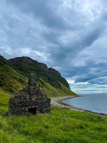
Bearreaig Bay, also spelled Bearreraig Bay, is a wild, stony inlet on eastern Skye, north of Portree in the Storr Lochs area of Trotternish. This is not a sandy swimming beach or a polished promenade: it is a fossil-bearing Jurassic shoreline beneath steep, layered cliffs, where loose stones, rock shelves and the Sound of Raasay set the scene.
The bay is reached from the coastal road via the Storr Lochs hydroelectric scheme and a sharply descending route to the shore. Its appeal is in the combination of geology, sea views and a compact but demanding coastal outing. The short distance can be deceptive; wet ground, steps and the uphill return make this a stop for sure-footed visitors prepared for rugged conditions.
Standout Highlights & What Not to Miss
Bearreaig rewards visitors who slow down and look closely. The shore’s Middle Jurassic rocks were laid down in a marine environment roughly 170 million years ago, and fossil-bearing sandstone and mudstone are the reason geology-minded walkers seek it out. Conditions shape the experience more than any fixed itinerary: a calm day brings clear coastal views, while recent rain can make the descent and stream crossing far more serious.
- Jurassic shore geology: Scan loose beach stones and weathered exposures for fossil traces, including the kinds of marine remains that give the bay its reputation. A recognizable find is never guaranteed, so regard the search as part of the walk rather than a certainty.
- Views across the Sound of Raasay: The open-water outlook is a major payoff, with Raasay visible across the sound and changing light often bringing out the texture of sea, cliff and moorland.
- Cliff-backed shoreline: The contrast between the narrow, stony bay and its steep enclosing cliffs makes the setting especially atmospheric for photographers. Keep a respectful distance from unstable cliff bases and avoid lingering beneath loose ground.
- The hydroelectric landscape: The approach passes infrastructure associated with the Storr Lochs scheme, adding an unusual industrial thread to an otherwise remote-looking Skye landscape. It is a useful landmark, not the destination itself.
- A proper down-and-up coastal walk: The stepped descent is memorable, but save energy for the sustained climb back. Sturdy footwear and a deliberate pace are more valuable here than trying to rush a brief photo stop.
Visitor Strategy & Planning Snapshot
| Planning Factor | What to Expect | Practical Strategy |
|---|---|---|
| Ideal Arrival Window | Clearer daylight helps with route-finding, shoreline detail and views across the sound. | Go early or later in the day for quieter photographs; avoid starting a descent when fading light could complicate the return. |
| Typical Time Needed | Allow roughly 1.5 to 2 hours for the outing, including the descent, shore exploration and climb back. | Build in extra time after rain, for photography, or if you want to inspect rocks carefully rather than simply reach the water. |
| Booking / Queue Reality | This is an independent outdoor stop rather than a staffed attraction, with only a small trailhead parking area. | There is no attraction-style visit to reserve, but arrive with a backup plan if space is limited and never obstruct the road or access. |
| Terrain & Accessibility | Expect steep steps, slippery uneven ground and a stream crossing; the route is unsuitable for wheelchairs and strollers. | Wear grippy boots, carry layers, and turn back if footing or water levels feel unsafe. This is not the place for casual beach footwear. |
| Weather / Seasonal Fit | Wind, rain and swell can quickly make an exposed shore feel harsher, while wet weather increases slip risk. | Check local conditions before leaving Portree. In wetter spells, treat the stream and muddy sections as potential reasons to skip the descent. |
Honest Trade-Offs: Best For vs. Who Might Skip
Bearreaig Bay is best for geology enthusiasts, experienced coastal walkers, landscape photographers and independent Skye explorers who value an unmanicured place. It offers a distinctive fossil story and dramatic scenery without requiring a long hike, but it asks for confidence on uneven terrain. Visitors expecting a level path, easy picnic area, sandy beach, reliable fossil finds or family-friendly waterside access may be happier choosing a gentler Portree-area viewpoint. It is also a poor choice for anyone with limited mobility, young children needing a stroller, or visitors uneasy on steep, slippery steps. Do not hammer cliffs, pry out embedded material or destabilize the shore; observing loose stones carefully leaves the site intact for the next visitor.
Neighborhood Context & How to Pair Your Visit
Bearreaig sits on the Trotternish side of Portree rather than in the town centre, so it works best as one rugged stop within a north-of-Portree driving day. Pair it with the wider Storr Lochs landscape and other roadside viewpoints along the peninsula, then return to Portree for a harbour walk, food and a more sheltered evening. Keep the bay as the active portion of the itinerary: complete the descent while you still have daylight and dry clothing, and avoid trying to squeeze it between tightly timed stops. Its value lies in giving Skye’s famous scenery a closer, more geological scale.
When planning your Isle of Skye travel guide or browsing verified attractions in Isle of Skye, pair this stop with standout local spots including Isle of Skye Smokehouse, smokehouse tours and tastings experience, Skye, Café Cùil, and Rigg Viewpoint (4.9 km away).


